
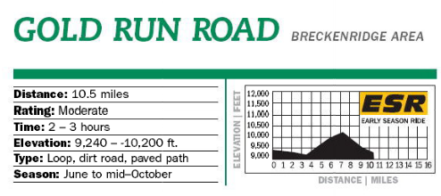
Know Before You Go: This area is usually the first to lose snow around Breckenridge and is often ridable by June. Large aspen groves also make this an excellent fall ride. Numerous side roads may make route finding a challenge and also provide some additional exploring. However, much of the land is private. To avoid endangering future access in this region, please respect all “No Trespassing” signs. Changes from this description may occur if there is development of the large lots located on the left side of Park Avenue.
Description:
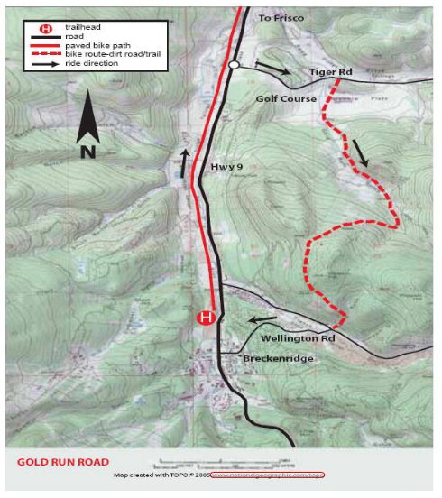
Get onto the paved recpath starting at Watson and bordering the west side of the river. Descend on it toward Frisco for almost 3 miles. Cross the Highway at the traffic light onto Tiger Rd. Ride almost a mile alongside the Breckenridge Golf Course and turn right onto Gold Run Rd. which winds along the left side of the golf course. Continue uphill to the junction, where you should bear right. Turn left about a quarter mile farther along the paved road.
Climb beyond the gold course and eventually ford a creek, which can be a bit challenging to cross in early summer. Pass the historic Jessie stamp mill and continue climbing, switchbacking right past a spur road on the left. Curve left and right before reaching the high point on Gibson Hill at about 7.2 miles. Stay on the main road, contouring along the forested slope. Continue straight at a major 4-way intersection and descend for about a mile along an aspen covered hillside. Eventually you’ll switchback right and merge with the well-traveled French Gulch Rd. Turn right and descend to the junction of French Gulch Rd., Wellington Rd and Reiling Rd. Stay left on the paved Wellington Rd. and follow it back to Breckenridge. Turn right on Main Street and then left on Watson and you are back where you started.
Parking:
If you are staying in Breckenridge. Follow Main St. North to Watson. Turn left and the recpath will be just South of river. From I-70 follow Hwy 9 south to Breckenridge. Turn right on Watson Rd. and park in one of the large lots located off Watson Rd.
Map & Information courtesy of Summit Daily, 2013 Bike Guide